ALPINE LAKES 2005, or:
Dr. B471l< and the 1337 H1l<3R5
I started off in the spring of 2005 thinking about doing a backpack into the Dutch Miller peaks. My plan was to hike the East Fork Foss trail through the Necklace Valley, scramble up to La Bohn lakes and then walk over to Williams Lake and Dutch Miller Gap, exit to Waptus Lake and go around Mt. Daniel and up to Deception Pass via the PCT, ending up hiking out to the Tonga Ridge road where I’d have stashed a bike to get back to the car. It would have been a serious nine day trip – but I had done various parts of it and the only piece that was a stretch was the scramble up to La Bohn Gap. I had done that years ago on the way to climb Hinman and I figured that if I scheduled it for a really short day I could do it and then come back down and carry Odette’s pack up. I remembered it as steep but not scary.
Will and I did a TOPO! route and profile and figured out where the camps would be, but then I kind of backed off because of scheduling confusion and the potential to team up with Art on a trip to the Pasayten. We ended up cutting a couple of days off the front end of our trip because Will wasn’t getting back from China until that Saturday and said he had a school meeting on Sunday. Odette booked a flight to Denver for 6:00 in the morning the Monday after the trip was supposed to end and I felt like she was hoping that we’d cut back on that end, too.
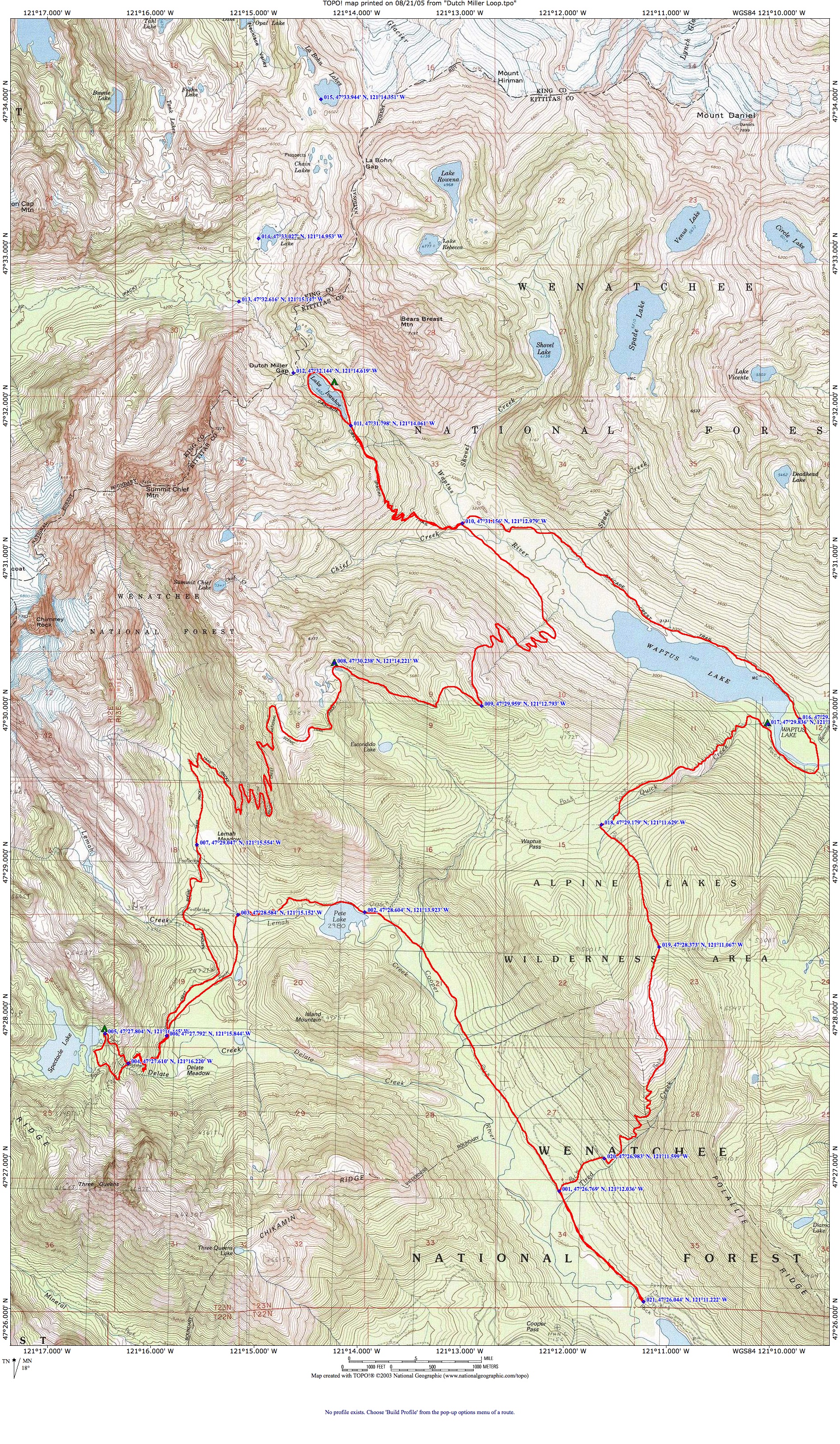
I toyed with going up the Middle Fork Snoqualmie to the gap and back via the PCT and Red Mountain pass. It would have been within our abilities, but with only one layover day and no margin of error on the final day over Red Mountain pass and down to the hot springs it seemed like it might be a lot of trail walking and not enough high-country exploring. I finally settled on going in from Cooper Lake, hiking to Spectacle Lake for the first night, then to Escondido ridge for the second night, followed by three nights at Lake Ivanhoe and then a night at Waptus Lake and out up Quick Creek and down Tired Creek. The first three days (and the last one) were a little bit long at 10 – 12 miles, but it was mainly on the PCT so it seemed like we’d be able to handle it. I didn’t exactly focus on elevation gain.
We didn’t really pack until that Sunday and then it was just the usual – Odette took too much clothing and we had more food and fuel than we needed. Odette made up three big first aid kits and we ended up taking two of them. I threw in full rain gear for all of us and a tarp that I could rig as a kitchen fly, because we were supposed to get drizzle Monday night. I took an ice axe because I planned to scramble Little Big Chief and La Bohn if I couldn’t get Will to do stuff with me. I lent Will a leatherman after he told me that he’d lost his swiss army knife to the TSA when he flew to Chicago the previous spring. It turned out that Will didn’t really have a meeting on Sunday. Odette wasn’t happy with my usual trail mix for lunch so I told her that she was in charge of snacks and lunches. We went to three or four different stores Sunday afternoon to get stuff and ended up with a different mix for each day. (We also ended up with a bunch of new clothes for Odette.)
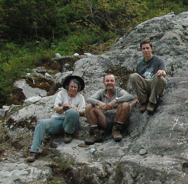
Lunches on a couple of the days were to include chocolate covered cherries but we ended up with chocolate raisins and didn’t think about melting temperatures. Odette swore that she was getting me a fruit/nut bar that I’d like in lieu of candy, but I discovered that they tasted like cardboard and ended up returning with all but one of them. Will wanted something other than trail mix so we let him get jalapeno tortillas, brie and mango chutney with the idea that he would put together a wrap each day. We put the chutney in a tube. Will had trouble getting all of his stuff in his pack and asked me for help. I stowed his tent in the outside compartment and then put his camera case on a side strap. All of the packs ended up too heavy – mine weighed 65 lbs, Will’s was 55 lbs and Odette’s was 35lbs.
On Monday morning we got up early and had large breakfasts at Beth’s Cafe on Aurora. We drove over the pass on I-90 (listening to Will’s music on his iPod shuffle.) We took the bullfrog cutoff and the Salmon La Sac road out to the Cooper Lake turnoff. We parked at the Pete Lake trailhead and put our packs on. The first few miles were flat and easy. We had lunch at Pete Lake. Odette objected to leaving the trail to get to the shore of the lake. The crossing of Lemah creek was cold but the water was low. Odette objected to that, too. I took my pack across, then came back and escorted Will while carrying Odette’s pack. Then I came back and walked across with Odette. She screamed. A little later, just after picking up the PCT in dense brush, she scared up a couple of yellowjackets that got me twice on my right shin. The switchbacks at the end of the day up to Spectacle Lake were brutal with our heavy day-one packs. We missed the unmarked “staircase” and took the main trail up to the lake. The map said it was an extra half-mile but it felt longer than that. Will’s GPS told us how close we were – as the crow flies. Odette and Will decided that ten-mile days were too hard and that it was my fault. That kind of became their mantra as we plodded along. Every time we stopped I hoisted Odette’s pack for her, Will’s pack for him and then my own pack. I ate a lot of huckleberries at the end of the line. The waytrail down to the lake was long and rocky but we found a spot near the water with views of Lemah, Chikamin and Three Queens. We set up camp as we watched clouds building over the crest of the range. We had dinner (but we were all too worn out to want ramen) and went right to bed. Will struggled with a broken zipper on his tent. It had been a 1,500 foot day.
In the morning clouds were still boiling over the crest. I shifted some stuff from Odette’s pack to mine but Will didn’t think he had room to take any more. He did after I put the tent on the side and put the camera on the front using the pack’s elastic cord. We hiked back up to the PCT and then down the switchbacks losing 1,000 of the 1,500 feet we climbed the previous day. We seemed to spend a long time in the bottoms of Lemah Creek. Eventually we came to an old burn that permitted views up to the glaciers on Chimney Rock. The sun was in and out of the clouds all day and occasionally those clouds spit on us. The switchbacks up from Lemah Meadows to Escondido Ridge weren’t steep but they seemed very long. I brought up the rear and once again had a lot of time for huckleberries. Every time we stopped and put our packs down Will had to be careful that he didn’t crush his camera and having it on the front of the pack meant he couldn’t flop his pack down and sit on it. We topped out on the ridge at about 5:00 and hiked a little way to a pretty little lake, but people had already taken the camp site there. We went on a quarter of a mile and camped in a spot where a trail party had evidently abandoned a tarp. It was an okay site with a view down to the lake but with a walk for water. Will took one of the summit packs and a pot and bag to haul water for us. Odette set up the kitchen on a slanted rock while claiming ignorance about how to set up the stove. I set up both tents, trying not to hurt the heather. I messed up the zipper on our tent. I broke the head of off one stake. We had climbed about 2,000 feet from the Lemah Creek crossing and we wanted the ramen with dinner that night. I read enough of the route descriptions to decide that the little lake was probably one of the Vista Lakes on the approach to Summit Chief. Even at that elevation Odette couldn’t get a cell signal.
It was cold overnight and we woke to frost on our stuff. There were no longer any clouds, though, so we had clear views of Three Queens, Lemah, Chimney Rock, Summit Chief and Bear’s Breast. Mt. Rainier was visible if you walked up the hill a little. We filtered water from a pot and packed up, with Will putting his stuff in Odette’s pack since it had more room. We hiked a couple miles on the ridge winding through the tarns and traversing above Escondido Lake. Mt. Stuart came into view as we rounded the ridge. Then we descended a bunch of annoying switchbacks to get down to the Waptus River – giving up all 2,000 feet we climbed the previous day and then some. Odette fell off the trail and ripped her pants while picking a huckleberry. I gave her a bad time for poor technique. After a short flat jungle section on the Dutch Miller Gap trail, we started climbing up to the Gap. Big creeks seemed to disappear in boulder fields and reappear on the wrong side of the trail. Odette began to slow way down so I pulled the sleeping bag (damn near all that was left) out of her pack and strapped it on top of mine. It was 5:00 again (after another 1,500 feet of climbing and plenty of huckleberries for me) when we finally found a camp site we liked on the east side of Lake Ivanhoe. We couldn’t figure out how to fit two tents on the dirt next to the water so we snuggled them together in the gap between a rock outcropping and the cliff below the trail. I ran a line from the top of the rock to a tree below the trail to hang the food bags. The sun went down early since the lake was in a hole, but it was warmer than it had been the previous night. Odette managed to break the zippers on both tents.
We slept in the next morning and didn’t get out of camp until about 10:00. We hiked on around the lake (looking for the shelter that was supposed to be at the head of the lake) and climbed through the waterfall to the gap. We stopped and rested at the gap and admired the scenery. We hiked down from the gap to the Williams Lake junction and then up to that lake. We headed around the right-hand side of the lake and stopped for lunch when the path petered out in boulders. Will and I hiked up to a tailing pile and looked into a mine there. The stuff in the tunnel was from relatively recent mining activity. The huckleberries from the last couple of days caught up with me and and I decided that abstinence was a virtue. Afterwards we went on around the lake and then hiked back up to the gap and down to Ivanhoe. We continued our circumnavigation of the lake still looking for the shelter. We found a set of nice campsites across the lake from our camp, but no shelter. We crossed the broken bridge at the outlet and got back to camp early in the afternoon and relaxed with tea and books.
The next day we got up early and hiked to Williams Lake again. Will and I left Odette there and climbed back up to the mine where we picked up the old miners trail to the Chain Lakes basin. We had to poke around a little to find the route in the trees, and then in the boulders we followed an abundance of cairns up to the basin. As we topped out on the lip of the basin we found a roofless stone shelter with lots of mining artifacts. We walked over to a flat spot above a smaller lake where lots of thick weathered planks were stockpiled. We walked from there to the main lake where tailings indicating a mine. The rocks at the outlet were stained red from the minerals in the tailings. The adits and shafts were fascinating – but not solid enough to make you think about entering. The rock was really interesting with many little crystals and colors ranging from red to purple and blue. A lot of it was really oxidized and there were metallic looking pebbles scattered around. We traced the vein over to another lake and located another open vertical shaft in the process. There were lots of artifacts scattered around.
We walked across immense slabs and then climbed the gentle ridge next to La Bohn Peak so that we could look down into La Bohn Gap. We walked around the wooded knob on the ridge until we could look down at the Necklace Lakes and Lake Angeline. We rested by a pretty little tarn at 6,000 feet. We had a 360 degree view and the Dutch Miller peaks were most impressive. There was a small sharp peak almost due north of us that I couldn’t identify – maybe Bald Eagle Peak. Mt. Baker was visible in the background. We continued to the La Bohn Lakes and then returned on the other side of the knob to the Chain Lakes basin. We picked our way around a couple of the other lakes, recrossed the slabs and went around another lake to the final adit. This one was solid but only went back a few feet. Then we walked back to the roofless shelter and started following cairns back down the boulder field to Williams Lake. We collected Odette there and hiked back to Dutch Miller Gap. On the way down to Lake Ivanhoe we stopped at the plunge pool of the waterfall and I jumped in – losing my bandana in the process. We turned left on the Ivanhoe Loop – still not having found the shelter. We had dinner early (including ramen) and afterwards I walked around the outlet end of the lake to the campsites we’d seen to explore them and see if there was a shelter on that point. There wasn’t.
In the morning we packed up early and headed for Waptus Lake. Somehow I was still carrying the sleeping bag – but inside my pack now. We were happy to get the switchbacks down out of the way before it got hot. The creek bottom before we got to the lake was impenetrable jungle – but I decided that I wasn’t abstaining from raspberries. All of the campsites by the lake looked too horsy and it was too early to camp so we decided to continue, thinking we’d stop when we crossed the Waptus River at the outlet from the lake. We had lunch at Spinola Creek crossing. Will’s brie was starting to get pretty strong. We were taken by the sign for Trail 1337 to Spade Lake which Will and I, at least, adopted as our new mantra. We found a nice site at the bridge but it was hot and there were flies and it was still early afternoon, so we filtered water and then continued along the river looking for something that would make the last day short. The trail was exceptionally dusty and there was a lot of horse traffic. We found one site we liked but there were horses in it. We found an even better one but there were hikers already there. We continued hiking and hit the Salmon La Sac campground at about 6:00. Will and I left Odette there and ran the five miles up the Cooper River to our car. We’d done about 20 miles, 15 of it with packs, and we were feeling 1337 indeed. We were back to Odette by 7:30 and then cleaned up in the river.
We got to Rosalyn before the Rosalyn Cafe closed and had dinner there. We drove back to Seattle and got home before midnight – a day earlier than planned. There was enought battery life left in the iPod to get us music all the way home. We didn’t get out on the bike the next day but we had time to do laundry and catch up on email and stuff before getting up at 4:00 the next morning to take Odette to the airport.
Here’s a link to a book list.
Here’s a link to some photos from the trip.
Here’s a link to the TOPO! route of the planned trip (showing us coming out up Quick Creek and down Tired Creek instead of our actual route down the Waptus River and up the Cooper River.)