| The southern trail-head at 110th. Seattle really ought to run the trail on down to Greenwood Park at 87th and Freemont since that park is themed on the Interurban. (The old right-of-way exists under the power line for much of the way.) If they are going leave it where it is at 110th they need to do something with the un-paved parking lot where the trail ends. You certainly wouldn’t know that this was the terminus of a major commute / recreation corridor from the looks of it. Let’s pave the parking, put in benches and tables, maybe drinking fountain and restrooms? (There is a nice little park across the street that would make a good trailhead park…) | 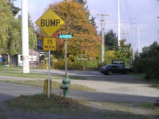
|
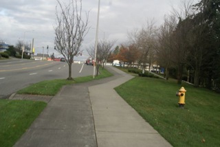
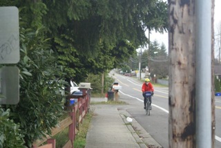
| The northern end of the Seattle segment at 128th and Linden. The right-of-way continues up to 130th – it’s just overgrown with blackberries and turned over to parked cars. Note that the main branch of the trail puts you out directly across the street from where the trail ought to continue. Instead you get “sharrows” as you climb up the street. | 
|
| Linden from 130th to 145th.
Seattle had an opportunity to connect their segment of the trail to the new Shoreline segment and they blew it. At the Bitter Lake community center the trail will come from the south on the west side of the street so it probably ought to go down behind the building. When the residences went up across the street to the east they could have made the developer put in a trail, but no…. North of the community center are residences for seniors (four freedoms house in particular) with parking under the power line. The trail should go there. There is enough room that you wouldn’t even lose any parking. North of that is a city reservoir. Clearly the landowner wouldn’t be opposed to the trail. There is a ditch next to the road that probably adds to the cost but the entire block is under development to the east and one of the conditions could have been roadwork to permit the trail. Instead we get sharrows and bike lanes that go nowhere. There are a lot of seniors in scooters on this stretch. There are a lot of kids at Bitter Lake. There would be a lot of walkers and skaters at the reservoir if the trail were reasonable. As it stands it is unsafe and unattractive. We can do better. (The Seattle Times identified this stretch as one of the top cycling hazards of 2010 in their “bike to work” article.) |
|
| Between 143rd and 145th Seattle put in a new sidewalk under the powerline. If that was supposed to be a trail (and the curb cuts line up with the trail at 145th) why wasn’t it regulation width? If it wasn’t supposed to be a trail (and it sure looks like a sidewalk) why is it in the interurban right of way? Either way, why isn’t the parking strip on Linden paved and why don’t we have a bike lane? | 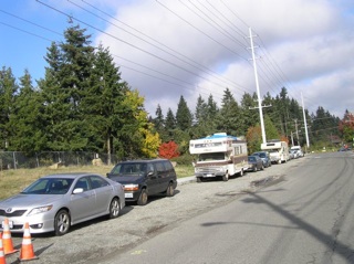
|
| Shoreline spent a bunch of money and built a really great trail segment. The bridges over 155th and over Aurora were designed by somebody who felt a need to get punitive towards bikes, though. Were those hairpin turns really necessary? At least on the one at the north end of the bridge over 155th the bikes could have gone straight. The way the turns are engineered makes collisions only a matter of time – at the top, and at the bottom – because you can’t see what’s coming. I expect that the idea was to force bikes to control speed but the penalty now is you wind up on the stairs if you go too fast. (Not that that’s a bad thing…) | 
|
| Another quibble about the Shoreline segment – instead of a regular crosswalk at 182nd we’ve got a curve over to Midvale and a crosswalk – or a much narrower and more abrupt right angle turn to the crosswalk next to Aurora. Again, I expect that the intent was to force bikes to control their speed. They should have just made the straight-ahead branch the regular width and put the crosswalk there. | 
|
| At the northern end of the Shoreline trail segment everything just comes to a stop – the trail dead-ends at a sidewalk on 200th. You can exit to the right onto Ashworth to make the right at 200th but you come out between parked cars and there isn’t any signage. The signage at the sidewalk isn’t clear either. The bike lane on 200th is too narrow.
The interurban right of way went on through the transit center north of 200th and ran next to the shopping mall, across Edmonds Way and then curved down to the lake. (There is a corridor just east of the transit center and shopping mall. Behind the Home Depot it looks like it is mainly occupied by a retention pond, but the berm on the east side is wide enough for a trail. the corridor comes out onto 244th right next to the highway department facility.) There is a steep slope where Highway 104 comes up so there may well have been a trestle. (Follow this link to see the right of way.) If we can’t have a bridge we ought to at least take the bikes through on the powerline right of way next to the shopping mall. If we can’t follow the curve down to the lake give us a grade separated trail next to Highway 104 to get back to 76th. |
|
| If you followed the powerline you’d avoid this, but the way bikes are routed now you take an apartment complex trail parallel to Meridian between 200th and 244th and then Meridian changes it’s name to 76th in Edmonds. This “private” trail is better than the bike lane on Meridian (especially going uphill,) but it doesn’t get maintained and the trail is covered with pine needles and leaves that make it really slippery. It is also really secluded (despite being right next to a busy street) and there are some weird people attracted to that stretch for some reason. | 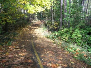 gallery gallery |
| The intersection of Meridian/76th and Highway 104 is really busy and the light is too short for cyclists. Signage isn’t great either. The real answer is a bridge or underpass further west where the interurban right of way went. Edmonds has been talking about building its segment of the trail for a long time now. They’re not going to fix this intersection. Maybe someday… | 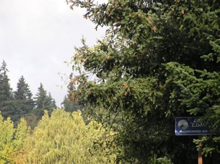 gallery gallery |
| The official route has you riding on 76th between 205th and 228th in Edmonds – but really the route leaves 76th at 241st because there isn’t a bike lane on 76th and southbound you’re on the wrong side of the street to get to the trail in Shoreline. You can see from the map that the Interurban right of way curves around from the shopping mall to cross 76th between 238th and 239th. I gather than Edmonds plans to build the trail under the powerline and leave 76th at that point. Now it is totally overgrown. | 
|
| Both the current route on 74th ave next to Lake Ballanger and the eventual trail under the powerline will put bikes onto 74th ave next to the golf course. This is a funny road that mainly runs by people’s back doors – meaning that there will be a whole bunch of driveways across the trail. The first part of 74th ave is actually separated into two strands – but dedicating either one of them to bikes isn’t going to solve the driveway problem. Part of the section of 7th ave (between 75th place and 228th) is an unpaved alley. It is rideable on a bike, even on one with skinny tires – but it’s really rough, especially where the potholes have been filled in with river rock. | 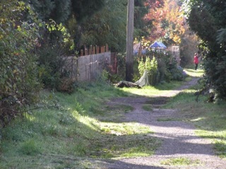 gallery gallery |
| Montlake Terrace doesn’t want cyclists to cross the street in the middle of the block so it doesn’t put in curb cuts and forces riders to make blind, right angle turns in an area where there are tons of Premera pedestrians. As if that fixes the problem. | 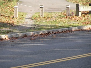 gallery gallery |
| At the northern Montlake Terrace city limits somebody built a couple of electrical substations on the old interurban right of way. The trail squeezes in next to the southern one but instead of continuing on the old railbed north of 212th the route detours out onto surface streets and cuts through a park before returning to the powerline. The crossing of 212th is better than it used to be but it is still not bike friendly. |  gallery gallery |
| Where the detour enters the park it passes through a chicane – presumably designed to slow down cyclists since anybody else would go around it on the grass. This obstacle course is too tight for tandems and pretty much causes any rider to daub with their feet. I wonder if it is handicapped accessible? Obviously the whole thing would go away if the trail stuck to the interurban right of way… | 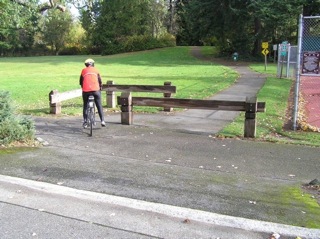 gallery gallery |
| Every few miles along the old roadbed the utilities have plopped down electrical substations. Most of the time you can get around them – but it obviously takes some money and some engineering to make them coexist with cyclists and pedestrians. Somebody needs to spend the money on the one at 212th. | 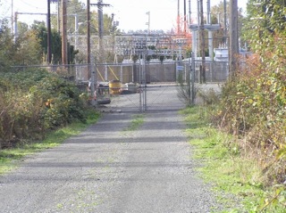 gallery gallery |
| Just north of the substation (between 212th and 208th) the trail used to accomodate both cyclists and cars accessing driveways. There is now a road to the west of the trail serving new houses but the pavement marking and signs haven’t changed. This one ought to be easy (and cheap) to fix! | 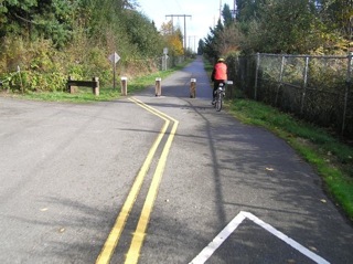 gallery gallery |
| At 208th the interurban clearly continued its straight line over to where the next trailhead is off of 52nd (you can see the corridor on the map.) On the ground it looks like people’s yards have encroached on the right of way and Lynwood has cyclists ride in bike lanes on 208th. There is an alley between 52nd and 53rd that ought to be opened up and paved since it lines up with the trailhead. (The intersection of 208th and 52nd is bad for cyclists and a dedicated crossing of 52nd would be safer.) | 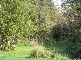 gallery gallery |
| At the Lynwood transit center the trail makes a very abrupt turn to the right onto a sidwalk and along 44th to a busy crossing (and then along 200th to trail again at Alderwood Mall blvd.) The interurban corridor would cross 44th right next to the freeway and avoid all of the traffic on 200th. Any reasonable design would at least line up the ends of the trail and the sidewalk. (UPDATE – in February 2010 construction has started.) | |
| The trail comes out by the Black Angus and goes north on the sidewalk (west side of 44th.) It should go under the on-ramps, across 44th, and then parallel the freeway. (The sidewalk is too narrow and 44th street is really busy.) After the trail crosses 44th (at a major intersection with lots of turning traffic) it goes along Alderwood Mall Blvd on a narrow sidewalk with heaves from roots and various encroachments from poles and utility boxes. You can ride in the street but the buses crowd you. After you cross a whole bunch of driveways you end up back at the freeway and reconnect with the trail right-of-way… | 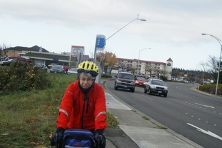 gallery gallery |
| There used to be talk of building a pedestrian / bike bridge somewhere south of the swamp creek interchange. This has evidently evolved into an expansion of the sidewalk on the existing 196th bridge. They’d be much better off putting the bridge a little further north (something like this) so that they could get the bikes out of the way of the cars and could hook up with the trail right-of-way on the east side of the freeway. | 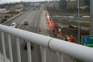 gallery gallery |
| From Alderwood Park Blvd on the west side of I-5 to the Maple / Butternut trailhead on the east side of I-5 the trail goes along the freeway to I-405 and then follows that to 177th where it goes under and then curves around to Maple which has a bridge over I-5. The trail gets dumped out into the street behind a Target and when it goes back onto a dedicated trail it’s narrow and overgrown. This little section of trail (often littered with abandoned shopping carts) re-enters Ash Way via a section of trail with a fence down the center segregating half for the adjacent landowners. The Maple bridge has almost no shoulder and too much traffic. The corner onto Butternut doesn’t have any space for bikes, either. The trail drops from the trailhead to the freeway where it turns right – on the left is a gate where the right of way continues – maybe to connect with a freeway crossing at swamp creek or 96th street? | 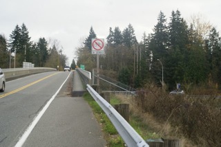 gallery gallery |
| From the Maple / Butternut trailhead the trail goes along I-5 to a point a little north of 167th where it cuts back up to Meadow Road (right next to the Eldec plant.) It should continue straight to a tunnel under the on ramp and then snuggle next to the abutment of the 164th bridge so that it could avoid the Martha Lake intersection. Meadow Road has bike lanes but they’re narrow and there is a lot of traffic. The Martha Lake intersection at 164th has way to many lanes and too much traffic. North of 164th the shoulder is intermittent and the left onto Motorpool way has no sight-line. As you reconnect with the trail next to the freeway on the left is a gate showing where the trail should go… | 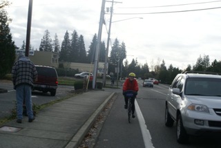 gallery gallery |
| From 164th to 128th the trail has no crossings. It comes back to surface streets at the drive-in where it empties onto Meridian Ave. It should go straight and under the 128th bridge abutment.
(As the DOT guy notes, people already go this way.) Meridian turns into 3rd and the intersection of 34rd and 128th is busy and dangerous. On 128th the trail either rides in traffic or on a narrow sidewalk with lots of driveways (watch out for real-estate open house signs with balloons that obstruct the whole sidewalk.) It picks up the access to the new bridge all the way out to where the cars enter I-5. It’s better than it used to be when you had to cross I-5 in traffic on 128th, but as you descend to the new bridge you can see where a tunnel under 128th would make life easier both for cyclists and motorists… |
 gallery gallery |
| From 128th to Everett Mall the trail is cool. The route around the perimeter of the Mall is better than dodging traffic through the parking lot. North of the Mall is a busy crossing of Everett Mall Parkway. On the other side of this busy street you’re on W. Mall Dr. with no bike lane (only a narrow shoulder) – but luckily little traffic. There is a lot of brush to the west where a dedicated trail could be built, though… |  gallery gallery |
| When W. Mall Dr. dead-ends you get a cool little dedicated trail up to 84th – a frontage road to SR-526 (the Boeing Freeway / Mukilteo Speedway.) There is a creek west of the trail and presumably a culvert to allow it to drain under the highway. They need to put in a tunnel big enough to carry the creek and cyclists.
84th has a narrow shoulder and no curb so that cars park right up to the fog line. You go a half-a-dozen blocks out of your way to get to 7th and Casino road which is the first underpass to cross under the highway. The intersection is complicated and bikes get routed onto the sidewalk (which is luckily pretty wide.) The trailhead to get back onto the trail is not obvious until you are right on top of it. At Pinkerton the trail puts you back onto the street. As you head down a 9% grade to get back to the right-of-way you can see where the tunnel should go… |
 gallery gallery |
| Between the Boeing Freeway and the end of dedicated trail at 44th you are on trail for considerable stretch, then on Commercial Ave, then when that becomes 55th you go back on trail. The stretch on Commercial Ave has wide shoulders marked for bikes. (The right-of-way is really wide on this stretch and a dedicated trail could be provided.) The problem is that each time you leave and enter trail there are gates to slow you down. (Where they just want to keep cars out they use bollards – the gates don’t have any other purpose but to harass cyclists.) They are navigable on single bikes but they make it really difficult on a tandem or a long recumbant. The crossing of Lowell doesn’t have any sight-line. There is a detour around a substation north of 52nd that involves three sets of bollards… | 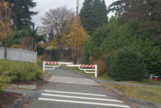 gallery gallery |
| Between 44th (with trailhead parking but nothing to indicate that this is the northern end of a major bike corridor) and 41st where the marked trail peters out, the route is on sidewalk. They have widened the sidewalk in recognition of the bike traffic, but it is bumpy and anxiety-provoking when you meet oncoming pedestrians or cyclists – and the driveway crossings are annoying. (Part of the sidewalk has a whole lot of really small pavers.)
It would be much better to route the trail next to the cemetary fence like Seattle did. |
|
| Here’s a discussion of the seven detours from the historic roadbed that make up the most serious problems with today’s Interurban Trail. |