Wayback Machine
AUG AUG SEP
Previous capture 28 Next capture
2007 2008 2009
15 captures
13 Jun 04 – 28 Aug 08
sparklines
Close
Help
Related Photos The Arctic Circle to Fairbanks, AK Stage (via the Dalton and Elliott highways) Back
May 20, 2004
The five hour drive to the Arctic Circle started at 6:30 am on Thursday, May 20th. Uncle Virgil drove the extended cab pick-up while his grandsons Caleb and Keegan came along to keep him company on the long drive home. Our tandem and trailer were packed in the back along with two gas cans, two spare tires and a cooler of food as services on the Dalton highway are limited this early in the season and the majority of our miles would be on gravel.
We stopped at the Yukon River to stretch our legs and admire the bridge. We reached the Arctic Circle around noon. It was sunny but nippy as the wind was blowing. We set up the tandem and trailer and posed for the “before” pictures. A few other groups of people arrived for their photo ops, including an army group on a team building venture and a tour group with a couple of guys from Michigan. After lunching on a nearby picnic table, we were off.
The first mile and a half was all downhill as we reached 46 mph. The adventure had begun and life was sweet. Then, we reached our first hill. With 2 miles at 9 percent upgrade, we crawled up that hill at 3 mph. We were not very prepared for the brutality of this hill. Because of activities related to moving our household items and finishing our jobs, our pre-adventure training was limited in Michigan. We arrived in Fairbanks on May 14th with three of four checked bags. Four days later, the bag with the remainder of our tandem arrived. Due to the luggage delay, we had time for only one, 15 mile test drive. There were some big hills around Barb’s Aunt Anne’s and Uncle Virgil’s home that gave us some assessment of how we and our equipment were working out. With the trailer fully loaded, the bike sailed up and down these rehearsal hills in a smooth and quiet manner.
So now, only miles into our adventure, we were being severely tested. We pedaled. We rested. We pedaled some more. We rested some more. Oh, what a challenge this hill was! While we were pedaling, the rear hub made random clicking noises and the pedals jerked. We had selected the brand of wheels for their rim integrity as we have busted rims four times before. Now the rim was fine and the hub was failing a mere 8 miles into our 7,100 mile journey.
Hubs are located at the center of the wheels. The hubs on the rear wheels of bikes are particularly important. They lock in one direction (which is necessary if you want the drive chain to propel your bike) and they turn freely in the opposite direction. In our case, the hub stopped turning freely and stopped locking in place – a cyclist’s worst nightmare. This hub had only 50 miles on it before it failed (very unusual) but we had no way of knowing of potential problems as it is hard to simulate 2 miles of steep 9 percent grade (as in climbing up) with a loaded touring tandem. The worst part about this occurrence was that we were 200 miles from the nearest bike shop. Fortunately, we had a back-up wheel back in Fairbanks. Unfortunately, we really stretched our relatives’ endurance to get that replacement wheel. Having transported us up to the Arctic Circle (a 400 mile round trip on brutal roads), they quickly rebounded with yet another 400 mile trip to deliver the wheel when we call them on our satellite phone. Meanwhile, with a grand total of 8 miles of biking to show for the day, we did the only thing that was available to do – set up camp at a location 60 miles from the nearest inhabitants. Randall didn’t help Barb’s sleep quality that night when he read from the Milepost (guidebook) route description that Grizzly Bears were noted to have frequented the turnout where we camped. With the tallest tree with branches to suspend our food at only 9 feet high, we secured the food in a bag at this height thinking, “OK, bears, you can have our rations, just leave us alone!” Randall shot pictures of the sun setting at 11:15 before retiring for the night.
May 21, 2004
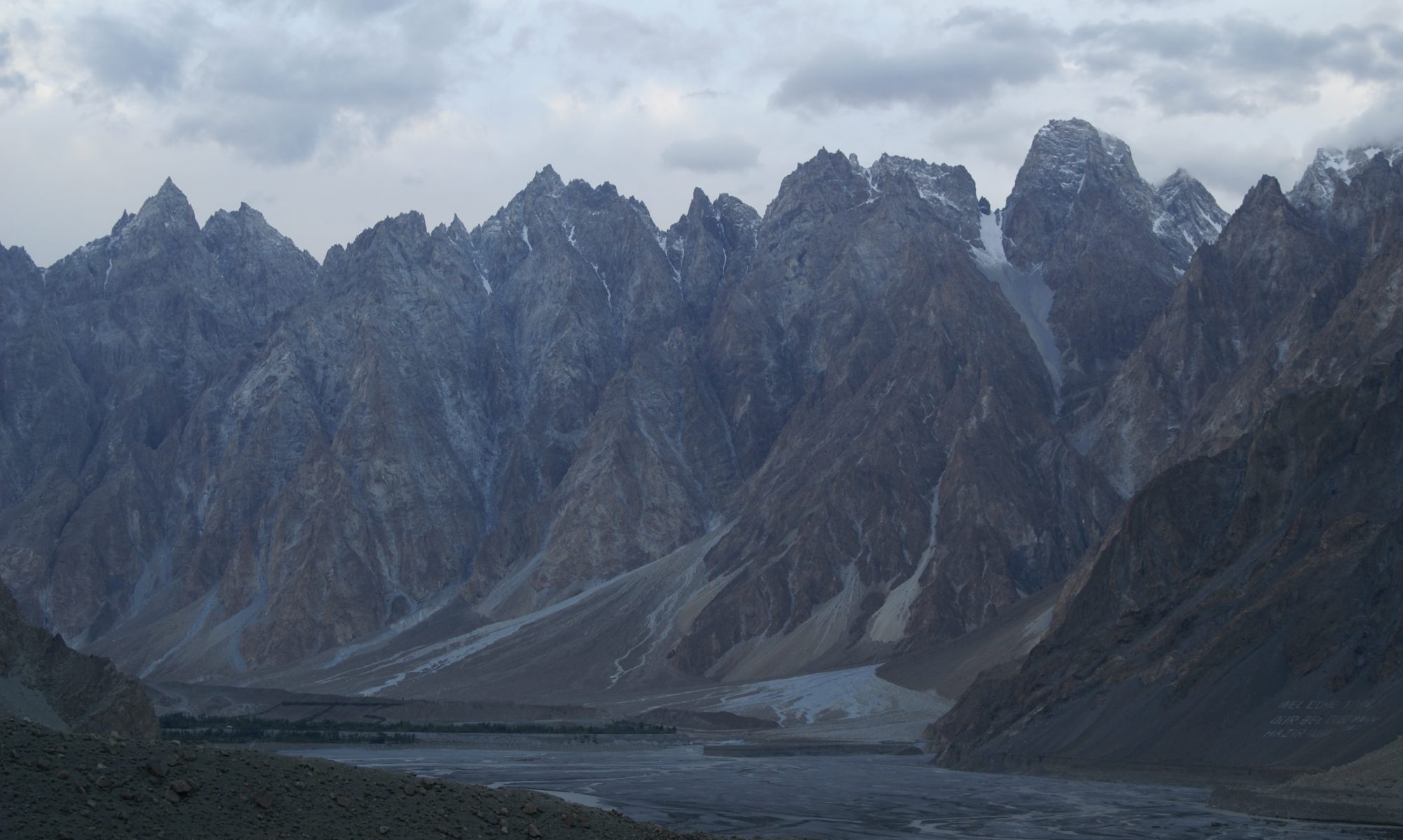
Having climbed the steep hill yesterday (the one that killed our rear hub), we had to conquer yet another one like it. Boy, talk about a boot camp for cyclists! We crawled up the ascent with one stop after one mile. Randall stretched out on the side of the highway for 5 minutes on that rest stop. He had met his match. Our reward for reaching the summit was a nice view of rock copings atop Finger Mountain. The landscape for most of the morning was partial snow covered slopes. There was a great sense that we were in the Arctic now! At 23 miles, we had a second equipment issue: the rear wheel was not quite centered and was rubbing on the frame. Having changed to a new wheel yesterday, we should have thought to check that. Not having the correct size washer needed for the centering, Randall bent a small S hook to act as a spacer. It should work until Fairbanks. While doing this repair, a vehicle coming from the North stopped and asked if we needed help. The couple was coincidently from Seattle (where we hope to resettle) and had a tandem in their utility vehicle. We had a nice visit and they gave us a couple of bottles of water saving us from filtering water that day.
At mile 25, the paved surface turned into gravel. We now have 90 miles of gravel ahead of us! At mile 34, we stopped at a service drive and cooked up macaroni and cheese and beef teriyaki for lunch. At mile 37, we descended a very steep downhill and had a third, more serious equipment failure. The brake cable going back to our disc brake blew off the rear caliper and small cloud of white smoke puffed out. Previously, we had 3 brakes. Now we had just the 2 rim brakes. We will have to deal with the disc brake when we reach Fairbanks.
With 50 plus miles today, we encountered a lot of semi trucks going back and forth from Prudhoe Bay. The drivers most always slowed down to reduce dust and reduce the chance of flying rocks. Our day ended with a stop at the Yukon River crossing. What a very impressive river in an impressive setting. We had diner at the local restaurant (the last services for the next 118 miles) and spent the night in the accompanying motel to rest our revolting legs. The accommodations were originally used to house the workers who built the pipeline and highway. Each room had two single beds and the showers were located in the men’s and women’s bathrooms. Not luxury, but much appreciated.
May 22, 2004
After a good night’s rest, we enjoyed breakfast in the restaurant. They usually don’t start serving until 9:00, but Val got up early to treat us to cereal, fruit and toast. We visited with a Habitat for Humanity volunteer who saw our trailer banner. He helped build several Habitat homes in Omaha. Later we meet up with Val again while she was driving to Fairbanks to take her grandchildren back home.
On one descent, we met up with three guys in a sedan. They stopped and flagged us down. Since it was time to cool the brakes, we stopped to talk. Paul from Scott Air Force Base in Illinois came bounding out of the sedan saying “Are you the Angells? The automotive engineers who sold their house and quit their jobs to bike to Florida? I read about you in the paper.” They were headed to the Arctic Circle but were unsure of the distance or what services were along the way. We showed them our map and explained where the services were. They did OK as they passed our camp that evening as they headed back to Fairbanks.
We stopped to prepare lunch at a double ended turnout. There was a pickup truck parked there but still plenty of room to set up our stove and heat the water for another dehydrated meal. After we finished eating, we heard voices in the woods. Two men with huge backpacks were returning from an overnight hunting trip. Andy and Kerry had bagged a black bear, dressed it in the field and were carrying the hide and some of the meat in their packs. We chatted a while and they poised for a photo before heading back to Fairbanks.
We soon encountered a three mile stretch of highway which had been watered down to reduce the dust. The mud was difficult to maneuver through, but fortunately this section did not contain any steep hills. The water truck passed us and was still adding water to the already slippery mess. We had been told this was happening, but had hoped that the maintenance crews were not out on Saturday, but no such luck. All we could do was smile and wave at the water truck driver as he was only doing his job. Somehow Randall kept us upright between rests on the scattered pull off areas which were not affected. We were so happy to see the dust clouds bellowing from an oncoming semi as this meant the muddy section was over. We used our drinking water to quickly wash down the bike. Once we got to Hess Creek, we filtered water for drinking and a more complete washing of the bike. The area beside the creek was muddy, so we used logs to create a walkway to the creek’s edge.
At 8:30, we set up camp near a creek not even mentioned in the Milepost guidebook. We had covered 44 miles and still had 12 miles to go to complete the Dalton Highway. Since we knew that included two steep climbs, we decided to stop for the night. The infamous mosquitoes had not been bad so far. Now they were swarming outside the netting of the tent. They were only on Barb’s side of the tent. The mosquitoes of the world over seemed to prefer Barb so Randall got some relief.
May 23, 2004
Before we started to ride, we noticed that the trailer tire was flat. It was just a puncture in the tube so it was easy to fix with our spare tube. We had expected more tire issues and had three extra bike tires and one extra trailer tire. We kept the tire pressure below that we usually use for pavement (as is also recommended for cars traveling the Dalton) and had only this one flat tire. The rest of our route will be on pavement, so we will reduce the number of spares and save us the extra weight and bulk. If we have issues and can’t get replacements, Barb’s sister Susan has a supply of tires (and other bike parts) she can overnight to us.
The last 12 miles of the Dalton Highway took nearly 4 hours to finish. Near the top of the first climb, an Alyeska Security vehicle (they run the Trans Alaska Pipeline) going north paused to say that it wasn’t far to the top. The Alyeska people and the semi truck drivers have all been courteous. Since the pipeline in under 24 hours surveillance and we have been photographing it often, we figure there is now a FBI file on us.
The second climb was three miles with varying 7 to 10 percent grade. With the loose gravel giving us some tracking difficulties, we walked about a third of the climb. Finally, we reached the pavement where the Elliott Highway begins. It was time for a picture of us with our tandem and trailer at the Dalton Highway sign. We positioned our bike and scouted for something to support the camera for a time delayed photo. Then, a northbound vehicle stopped and out jumped Val from the Yukon River Cafe. She happily took our photo.
Pavement at last! The northern section of the Elliott Highway is in very good shape. That’s compared to Michigan roads which see less weather extremes. After advancing 5 miles on pavement, we remembered to increase the tire pressure now that the gravel roads are behind us. At about 5:00 p.m. it begins to sprinkle. We continue until 7:00 when we camp in a turnout which leads to the Grapefruit Rocks. The area is wooded with a strip of trees between us and the highway, so we’ll have some privacy. But at the price of mosquitoes! We manage to start a fire in our stove despite the light rain. We are in bed by 8:30. A steady rain continued all night and the mosquitoes swarmed between the rain flap and the netting, where they are dry but not fed.
May 24, 2004
We wake to rain and wondered why we didn’t think to place some firewood inside the tent flap to keep it drier for the morning meal. Lesson learned. We still manage to start a fire and have vegetable lasagna for breakfast. We finished the dehydrated eggs the morning before and have one more packaged meal reserved for lunch before we will make it to the Hilltop Truck Stop 35 miles away.
The rain stops as we start our ride, but the sky remains overcast that morning. We are still getting encouraging honks from truckers who have been following our journey for four days now. By afternoon, the sky is clear and the temperature starts to rise. Soon we are biking in our shorts and short sleeves, regretting that we left the sunscreen in Fairbanks because the first leg of our trip was suppose to be cold. We reach the Hilltop Truck Stop after a long, steep climb (the name was an indication) with one candy bar to spare and set down to a truck-driver-sized dinner. Unfortunately, that doesn’t leave any room for a piece of one their famous pies. While we are inside, it absolutely pours outside (and we left the windows down!). We move the bike under the overhang and resume our meal. When we leave, the temperature has dropped 15 to 20 degrees and we are once again covering our arms and legs.
One more glorious downhill before we stop at the Alyeska Pipeline Information Center in Fox. We have been following the pipeline for 200 miles. The Dalton Highway only exists because it was needed to build and maintain the pipeline which is why the locals refer to it as the “haul road.” Roughly half the pipeline is above ground (as commonly seen in photos) and includes heat fins to keep from melting the permafrost below ground. The supports also allow for movement due to temperature fluctuations or earthquakes. When permafrost is not present, the pipeline is buried. In the spring, the area above the buried sections is warmer and greens up first. As engineers (albeit currently unemployed engineers), we are fascinated by the technology involved and spend some time looking over the displays and a section of the pipeline made accessible to tourists.
We made it back to Barb’s aunt and uncle’s home about 9:00 p.m. (still very light in Alaska) to the relief of many relatives.
Related Photos Back