GOAT ROCKS LOOP
2004 did not start auspiciously. PASC sold to ACS in January. The euphoria and hard work of making the deal happen were quickly replaced by the struggle to adapt to big-company policies and loss of personal control. I skipped the Phoenician in January to teach snowboarding to adolescents at Snoqualmie Pass. It seemed like all of my backcountry ski trips got weathered out. We finally realized that the PSIA seminar in Sun Valley during spring break just wasn’t going to work – so we went to Whistler for a long weekend instead. I lost my iPod there. I signed up to lead a couple of climbs and a couple of scrambles but my heart wasn’t in it. I agreed to go on a trip to the Pickets that Jeff had been trying to sell for more than a year. Jeff rescheduled the Pickets trip to conflict with a climb and a scramble I’d just scheduled. I rescheduled my trips. By June I was in the middle of conversions, budgets, audits and take-aways. I was five pounds overweight because I hadn’t been able to get out all spring.
Odette was not much better – she was struggling with parents and siblings and work issues and was cycling hard to get fit. She wanted to go to Colorado in August and take a trip with Will before school resumed in September.
Will was planning to take the second level Java class at the University of Washington, and we told him that he had to get his community service and outdoor requirements out of the way – so he signed up for a canoe trip in July.
Then things changed.
Will got invited to a Knowledge Bowl competition in Orlando that conflicted with his outdoor trip which he rescheduled to August thus nixing the trip to Colorado. Then he got a summer job which nixed the Java class. Odette gave up the trip before school, but decided that instead we should all three go on a backpack. We settled on a week starting on a Tuesday in July and ending on the next Monday. Will told his new employers in advance. Odette scheduled the time off from her job. ACS decided that they would have the kick-off meeting for the new fiscal year in Los Vegas right in the middle of that week. I said I couldn’t go and they said – okay.
None of us really had time to to think about gear or packing until right before the trip. We went to REI and Will and I stuck a bunch of freeze dry into a basket. Later we realized that somehow we’d gotten a vegetarian rice pilaf so we substituted a chicken-with-rice left over from the previous year.
So the morning of Tuesday, July 20, 2004 found us sitting in an IHOP in the U district eating greasy half-cooked hash browns and limp bacon. I didn’t leave a tip for the surly waitress. We drove to White Pass under overcast skies with a little rain. I got stopped for speeding but the trooper let me off with a warning (73 in a 55 zone).
We left the highway at Clear Lake, missed the turn and drove for a few miles on around the lake. Will’s GPS wasn’t too much help but we finally realized that we needed to go back, found our turn, drove to the end of the North Fork Tieton River road and parked. I was nervous about the route we had planned. We had seven days and I wanted to spend it in the Goat Rocks because I hadn’t been there, Odette liked the William O. Douglas Wilderness next door, and this seemed like a place where Will and I could scramble things and Odette could hang out with the mosquitoes. Plus she really wanted to see mountain goats in the wild. The idea was to do a circumnavigation. Manning’s book on the South Cascades had a whole bunch of hikes in the area but no seven-day loops. The Trekking Washington book had a three day trek that fired my imagination – according to it, the highest and “most dangerous” stretch of the Washington PCT (pacific crest trail) runs through the Goat Rocks. But they described a one-way trip and the crest section of it was only five or six miles long. I studied all of the climbing books and hiking guides I could find for a loop or a base-camp that would keep us busy for a week. Then in Beckey I saw a mention of a “faint trail” from Cispus Pass to Surprise Lake. That was the missing link to a loop combining both the popular western approach through Snowgrass Flats and the eastern approach through Conrad Meadows. The only question was whether Odette could handle a Beckey “faint trail”. I outlined my thoughts to Jeff and he said “well I can see it on Beckey’s sketch map.” The deciding point was when I looked at WTA trip report and found someone from a couple of years ago who reported that it was fairly easy to follow the trail except through high grass in the meadows. (After the trip I found that Bob Dreisbach described the faint trail in his book. Odette knew Dreisback as an old man from Meany and it would have calmed her to know that someone like him had hiked it.)
I didn’t tell Odette about the route until we were packing the night before the trip. Then I showed her where it appeared on the sketch map and showed her the WTA trip report. I also didn’t show her the “highest and most dangerous” description until we were in the car on the way south.
Despite a lack of planning, we went light – no tarp, no extra books, not a lot of fleece – just freeze dry and ten essentials. My pack was about 65 pounds leaving home, Will’s was about 50 pounds and Odette’s was about 35 pounds. About a third of our total weight was food and fuel. We took a 40 oz. freeze dry and three servings of cup ‘o soup per day along with five oz. of trail mix, two cliff bars, a portion of oatmeal and two portions of candy for each of us. (We actually had a little more trail mix than that since it consisted of two parts rice crackers to one part almonds and we filled four wide-mouthed plastic bottles that originally each held 40 oz. of Costco cashews). We took ice axes for Will and me and a ski pole for Odette. Odette and I shared a tent and sleeping bag; Will carried his own. Will and I both took digital cameras. Will had his GPS. We did take the thermorest chair kits.
Leaving the car with heavy packs we hiked a gentle trail to Tieton Pass and then took the PCT south to a junction with the old trail into McCall Basin. It was hot and buggy but the trees shaded us. The trail was really dry climbing to the pass. On the PCT we met a couple of guys heading for White Pass. We descended slightly into the basin and dropped our packs in the first campsite to scout around and find a place to stay. We settled on a site on the bank of the stream that wasn’t too horsy. Odette stayed at the campsite while Will and I retrieved the packs. After a couple of attempts to just clip her pack onto the back of mine I strapped it under the top pocket and staggered back to set up camp. We had soup and then lasagna and went to bed early and tired.
In the morning we went looking for the waterfall shown on the map and found it so far down in the gorge that we couldn’t approach it. We hiked over the ridge into Glacier Basin and began looking for a way to cross the stream. As we moved upstream we had to navigate several rocky benches that left Odette unhappy. Then we climbed to the top of the upper falls in brush and rock and snow – which left her scared. Then we traversed the top of the basin on snow and boulders which left her refusing to proceed. So she sat and waited while Will and I climbed scree and snow to the top of point 6728. (It looked like it should have been Tieton Peak to me on the way up, but Will’s GPS quickly informed us that there wasn’t anything that big anywhere near.) We had a glorious view of Rainier and the basin and we identified Curtis Gilbert, Goat Rocks, Ives, Old Snowy, Egg Butte, and the McCall glacier. We descended quickly startling Odette with a yodeling glissade. She got her feet wet when she broke through a snowbridge on her way back and we chided her for not following in our steps. Then we walked in circles on the next snow patch we came to. The cliffs were easier on the way down and we were back to camp by late afternoon. We found two young ladies and a dog in the stream by our camp. They were surprised to hear that we were heading south on the PCT. We ate beef stroganoff and went to bed early.
Packing up in the morning we found that the buckle to Odette’s hip band was missing, evidently lost when I was wrestling with the weight of our combined packs. I jury rigged a replacement with cable-ties and we continued. We hiked back up to the PCT and then headed for Elk Pass – a schlep with our still-heavy packs. There were a lot of blowdowns on the trail which surprised me. The guides say that you want to hike this country before it dries out enough for horses – perhaps they don’t maintain the trails until the horses can get in, too. The trail climbed to the ridge giving views into McCall Basin and then over to the west side of the crest we had looked at the day before. Finally we saw Rainier and then we crossed a ridge and dropped into a basin before climbing back up to Elk Pass. Odette went slower and slower as we got higher. I snapped at her and told her that I didn’t mind her stopping a lot and I didn’t mind her going slow but she couldn’t do both. We came to a couple of small snow patches that she didn’t like and she declared that if she had to cross one more she was going to sit down and wait for a ranger. I wished her good luck. Will waited for us at the pass.
The next section of the trail was incredible – high traverses across scree fields, winding in and out among rock towers, keeping mainly to the ridge. In places they’d leveled off the ridge top and we walked for long stretches next to the top of the glaciers on the eastern slope. In places we went up and down steep shattered rock to get around gendarmes. As the book said, you wouldn’t have wanted to meet a horse party. At the first resting place I ran the ridge out to the top of Egg Butte. We met a guy who bragged abut his speed and we recommended McCall Basin to him. He said he had hiked the trail (instead of taking the shortcut across the Packwood Glacier) to see what it was like and that it was rocky. We met a pair of guys going slowly who said that they had crossed the glacier and that it was frightening (“if you fall you die!”).
When we got to the shortcut I said that we should follow Harvey’s recommendation and climb above the glacier on the rocks. Will and Odette were tired and insisted on the snow. I acquiesced. The first part wasn’t bad, but the second snowfield ended with a rising traverse on steep snow under a corniced ridge with no run-out. (At least I couldn’t see the run-out since it dropped too steeply, but it obviously ended in rocks since there was a boulderfield visible way below us.) I connected two fifteen-foot sections of webbing and tied myself to Odette. I figured that if she slipped I could probably hold her and with my ice axe. We crossed just fine but I was anxious all of the way, probably more anxious than Odette was.
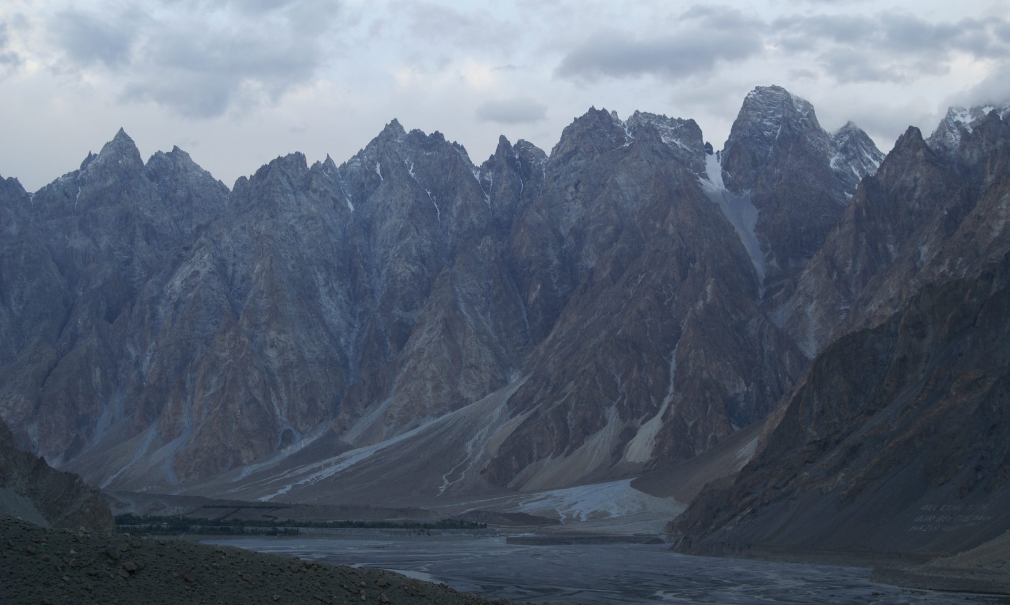
A little way below the exit from the snow we found a rudimentary shelter and running water so we rested and I pumped. Mt. Adams and Mt. Rainier were right THERE. I can’t remember if we could still see St. Helens. We could see a spectacular frozen lake across the valley (Mt. Johnson – where the goats are according to Beckey.) The crest of the Goat Rocks was just above us. I told Odette that I was disappointed that they hadn’t been willing to take the trail in the rocks since I would have climbed Old Snowy from the high-point and would have tried to talk her and Will into coming with me. I think that I said I felt “cheated” and I know that whatever the word was, she got offended . We saddled up again and continued toward Snowgrass Flats – past a closer frozen lake, past a collapsed shelter, over more snow and down into the greenery. It had been a long day when we finally came to the junction with the Snowgrass Flats trail and found tents pitched close by. With Will grumbling in the background we continued on the crest trail for a quarter of a mile until we found a very nice site out on a promontory under big trees with a view of Adams, the Goat Rocks crest, and the valley leading to Cispus Basin. There wasn’t a lot of water but there was a small deep pool to dip from a hundred yards away from the tents. We set up camp and hung the food bags. The meadows around and below us were full of beargrass and lupine and paintbrush and scarlet gillia and anemone. The sunset made the crags of the crest glow orange. It was pretty cool.
I got up at 6:00 the next morning, made tea, and at 6:30 I was hiking past the junction with the trail to Snowgrass Flats. I hiked to the high-point on the crest trail (which was adequately maintained and easy enough to follow) and then walked up the ridge to the top. There was a breeze on top but I stopped to put on sunscreen and dark glasses. I followed the ridge down to the saddle with Ives, detouring to the west around gendarmes and steps. Just after leaving the top of Old Snowy there is a peculiar arch made of crumbly, glassy, rock that is almost cobalt blue. From the saddle I walked up the ridge to the summit of Ives. The summit block was a hundred-foot cliff but it was obvious that if you could get up on the south slope it would be easy. I tried the first gully and quickly got into hard climbing so I backed off and walked on around until I could do it the easy way. The south slope was steep but made up mainly of small flat talus fragments. I walked easily to the top and spent a few minutes admiring the view and orienting the map and identifying the stuff we’d seen from Glacier Basin.
I descended from Ives following the ridge but staying further east. There were a couple of big snowfields that were gentle enough for standing glissades. There was a steep dirty red slope to traverse to get into the upper Cispus basin. I traversed around the head of the basin on dirt and snow and then climbed the ridge on the other side. I topped out on the ridge just below where it met the Goat Spires and maybe half-a-mile east of Cispus Pass. I read the descriptions in Beckey and Smoot and wasn’t sure how far over the “obvious gully” might be so I descended steep snow on the other side, then crossed the snow and contoured over to the first big gully after the ridge. As I was getting over to it I heard rockfall and saw a cloud of dust – and then realized that there were a bunch of goats going up the gully in front of me. I figured that the goats probably knew the best way up so I followed them, staying to the side of the gully to avoid the rocks they kicked down. I kept looking up and seeing goats perched improbably on the tips of slender spires. The gully got steep and crappy. I threaded my way back and forth picking the easiest ascent. The right side was wet and muddy from melt water. The middle was a bowling alley. I climbed a fourth class step, angled left at the top and found a cairn. I climbed some steep loose wet rock to another cairn. My mantra the whole way up was “a crappy pile of rock – with mountain goats on top.”
At a fork in the gully I could see at least a dozen goats kneeling on a big ledge a few hundred feet above me. I took the left-hand fork leading directly to the goats and presumably to a hidden snow basin. I quickly found that the gully was full of snow but I was able to climb in the moat on the left side. As I neared the top the goats started to spook and in small groups they bounded across the snow above me and disappeared up a ramp to the right. I got up to their crossing and realized that I didn’t want to be on that snow. As easy as the goats made it look, the snow was very hard under the top inch, very steep, and very rocky at the bottom. I realized that I was off route and I figured that I should probably head back down to the bottom of the snow and take the right fork of the gully. I couldn’t see if it really connected but it appeared as if it would put me on the ramp the goats took. It was a long way down and back up, though, and I couldn’t figure out where the top was. I thought about just giving up and returning to camp.
After considering things for a while I continued up to the goat ledge and found that there was a moat around the top of the snow – although I had to stem between the snow and the rock for maybe a hundred yards. Just below the most difficult part was the opening to a tunnel that cut across fifty feet and exited on the other side. The walls must have been very thin because it was bright blue inside. I thought about crawling through the tunnel (it was maybe five feet tall and perfectly circular,) but I was concerned that the walls were so thin that it might collapse sending me down the slope so I stuck to the moat. As I kicked steps for my right foot I was concerned that I was going to go through and break out the walls of the tunnel. After I got around the top the moat widened out and eventually I exited it to the goat ramp. The ramp topped out just to the north of a cliffy flat-topped block called Goat Citadel. The guides said to pass that on the south so I walked around just below it on easy ground and found that I needed to descend a hundred feet or so on talus to a saddle between Goat Citadel and the Curtis Gilbert summit block. First I walked up the easy side of the citadel to look at the slender stakes protruding from the top. They were county line markers.
I descended to the saddle and then climbed a sandy slope to the summit block. Despite what it says in the guide I had to traverse half way around to get to rock that looked like I could scramble. The last couple hundred feet were easy and the view was great. I ate my trail mix and a cliff bar. It was about 2:00. Although I knew it went, I wasn’t very interested in going down the way I had come up. I decided to head down to the saddle and then descend Beckey’s obvious gully.
Heading down from the summit block I followed boot tracks and cairns on the southwest corner. As the ridge leveled out below the summit block it seemed like a long ways around to get to the saddle and I kind of followed the track due west. When the climbers trail turned south to follow the ridge crest I continued west thinking that maybe I could just drop the four- or five- hundred feet to the valley bottom. As I headed down the talus slope I realized that I was eventually going to get cliffed out and that I either needed to head back over to the normal route or I needed to follow the track. I pulled out the route descriptions again and then decided to follow the ridge south until I could see a way down.
The ridge was broad and flat and easy going, with county line markers most of the way. Every time I looked into a west-facing gully I ended up deciding not to head down because of the visible profusion of spires and cliffs. I continued south on the ridge for a couple of miles (and a couple of hours) generally bypassing bumps on the left (east) side. As I got further and further from the summit I got more and more interested in seeing where Becky’s “faint trail” crossed the ridge. The east side of the ridge was steep and mainly snow-covered and I was concerned about how I was going to get Odette down it. I finally started to see gullys on the west that I thought I could get down but I decided to continue on the ridge until I found the trail. I scared out a couple of elk (I didn’t see them but I heard them take off down the right side of the ridge) and then, in a meadow full of lupine I found a pair of big cairns on the east side of the ridge. The descent here was short and snow-free. I could see a trail entering trees at the bottom, only a couple hundred feet below me. I could see a trail on the valley bottom beyond the trees. I walked part way down the slope and couldn’t see where the trail went down but I figured that it didn’t matter because Odette could just walk straight down. I had to poke around on the west side of the ridge for a while before I found the trail down hidden in the lupine and cedars. There weren’t any cairns but the tread was clear. Shortly after starting up the trail I ran out some more elk, again hearing but not seeing them. The trail dropped down through the cliffs and then leveled out. In the rocky sections it was well marked with red paint blazes on rocks. I tried to kick branches off as I went. It was obviously well traveled by game and there were well developed bypasses around the blowdowns. At one point I got off track and ended up going down through a thicket in a wet area. As I came out of the brush at the bottom I saw two bull elk just ahead of me, grazing in a meadow. They didn’t startle so I got the camera out and then had to whistle at them to get them to raise their heads for the photo. They both had huge racks. I continued on the trail, basically contouring along at the same elevation, generally loosing the trail when it crossed a meadow and picking it up when it entered the trees on the other side. I finally came to the basin below the gully where I’d headed up in the morning (the source of the Klickitat, in the Yakima Indian Reservation.). As I came out of the woods I realized that the basin was full of elk. I counted forty sleek, fat, horse-sized animals slowly moving downhill as I approached. At least that many more went up and around. The whole headwaters of the Klickitat smelled of musk and elk piss. I bashed through the trees, crossed the creek on snow and contoured around the other side of the basin. I scared out a couple of deer before starting the switchbacks up to the top of the ridge. The trail was hard to follow as it got nearer the ridge top but in the scree there were terraces visible and I followed them until I hit the abandoned trail again just before the top. I stuck an old signpost upright to mark where I’d left the trail and then hopped over the snowbank at Cispus Pass and onto the crest trail. It was about 6:00 when I hit the crest trail and I sat long enough to eat a cliff bar then headed back for camp as quickly as I could. I covered the three miles in a little over an hour, stopping at a waterfall to wash my head and face. Odette and Will had waited for me for dinner. They had walked to Snowgrass Flats and back – less than a mile – and then sat around and read all day.
In the morning we packed up and headed down the trail to Cispus Pass. We took the abandoned trail and worked our way down into the basin. We met three climbers in the basin who were backing off after attempting Curtis Gilbert. At one point we saw a couple of cow elk. We smelled the others. We had a game going about the red paint blazes. Odette found the trail steep where it climbed up through the cliffs. I dropped my pack and came back to carry hers. At the top of the steep part there is a section that looks like it could have once been a road – wide and flat and nestled between a boulder field and some big slabs. We had as much trouble getting through the cedars and onto the ridge top as I had experienced the previous day finding the start. We rested on the top of the ridge and Will and I replenished our water bottles with snow. We headed down to Surprise Lake and after we got down the slope we realized that the trail cunningly stayed right at the edge of a boulderfield. We connected scraps of trail until we came out on a dusty, heavily used trail which we followed to Surprise Lake. At the lake we passed two men with horses, one of which was down on its side with the guys pulling on a leg. Neither the guys nor the horse looked very happy. We decided to continue, intending to find the junction with the other branch of the Surprise Lake loop, and to camp there instead of at the lake. We never found the junction but continued on a horribly dusty horse trail all the way down to the bottom of the valley. (Harvey warned us.) It felt much longer than it appeared on the map and the trail never got close to the creek after the outlet from the lake. When the trail finally returned to the creek we crossed a bridge and followed a way path into the brush to a marginally acceptable clearing next to the water. I tied young cedars down to give a free-hanging space for our foodbags. The tents were almost touching each other but we slept well that night, too.
The next morning we discovered that we were very close to the Conrad Meadows trailhead. This is how I imagine William O. Douglas country – dry and high and open – made for horses and for exploring. The valley opened out as we approached Conrad Meadows with really nice campsites and the river looked inviting. We had a slight dispute about which Conrad Meadows trailhead we were at, but Will and his GPS proved correct as usual. After walking about a mile on the road we found the Bear Creek Mountain trailhead behind a gate. We headed up and it was hot and dry but not as dusty as the previous day. We drank all the water we had and at about noon we finally came to a meager creek (really more of a seep) and I filtered water for all of us and an extra liter for myself. Less than an hour later, after crossing several much better creeks, we came to a nice camp site at the junction with the trail to the lookout. We rested but didn’t head for the summit. We hiked on a couple of miles in gorgeous meadows looking for an established campsite with water. We finally found water but realized that we’d missed the junction with the trail to the North Fork Tieton. We retraced our steps to the junction and camped there in trees. The bugs were bad and we must have looked pretty funny with all of our fleece and headgear when a group of horsemen rode up doing trail maintenance.
The next day we headed down to the North Fork Tieton. The trail was good and most of the blowdowns had been cleared. Downhill and with light packs we made good time. Shortly before noon the trail deposited us on the bank of the river – maybe 100 feet wide and with strong current and a lot of water. We looked around and found debris from a bridge. I crossed on a logjam downstream where there were big logs twelve or fifteen feet in the air. Will followed me when I came back for Odette’s pack. She didn’t want to be up that high and scooted herself across on smaller logs just above the water. Will and I laughed as she struggled with branches and cross logs.
The cars were ten minutes from the other side of the river. We rinsed off and changed shoes and shirts and then headed for Yakima with one full jar of trail mix and a bunch of extra cliff bars. We stopped for milkshakes in Natches and then took I-90 to Seattle. We got back to town just before 5:00 and headed straight for Dave Page in Fremont where I dropped off my boots. (The liners had completely disintegrated in the heels and they kept balling up and bothering me.) I had a climb of Snowfield scheduled for that weekend and the cobbler said she would have my boots ready for me in three days.
During the trip I took well over 100 photos. Will took almost as many as I did. When I got home I downloaded them and Odette ordered a few prints for her father. A couple of weeks later, while I was on a trip in the Picket Range, our house was burglarized and both my computer and Will’s were stolen. All of our photos of the backpack were lost with those computers. At the end of the month Will and Odette visited her father in Colorado and Will photographed the prints she’d given him. Here are the only images we have.
Here’s a book list.