SPIDER GAP TO HOLDEN
The week before labor day in 2000 Will and I hiked from Phelps Creek to Holden.

On Saturday morning Odette dropped us off at the Phelps creek trailhead (about three miles from the old mining town of Trinity.) It was a day of broken clouds with a forecast of unsettled weather for the weekend followed by warm and dry days on the east slope of the Cascades.
We hiked to Spider Meadow – five miles in about five hours. There were a couple of large groups there and it felt like the meadow was teeming with people. Most alarming was the number of dogs – which I thought were not allowed in the wilderness area. We dropped our packs in an established campsite (near the toilet at the lower end of the meadow) and went off to see if we could find something better. After exploring for about an hour we settled on a dark tent spot in the woods just below the junction where the trail to Phelps Basin and the trail to Spider Col separate. There wasn’t any water but it was off the trail and there wasn’t anybody else around. I went back about a mile and retrieved our packs. I strapped Will’s on top of mine and hauled them both (100 pounds?) up to the new camp. That heavy of a load works a lot better if it is centered and stable! Our freeze-dry that evening was lasagna.
The second day we hiked to the foot of the Spider Glacier. This was a short hike (a little over a mile?) but it was a steep old miners trail that took unpredictable turns and wove in and around cliffs. We camped on a knob at the foot of the glacier which meant we had to climb down to get water but had a stupendous view. After setting up the tent we took our lunch and scrambled up to the ridge, first over slabs and heather, then over boulders and snow. It was windy at the top but we had a great view of Phelps Ridge, Red Mountain, Chiwawa, Maude, Seven Fingered Jack, Dumbell, Fernow and the various basins. I understood that there was a scramble route from Chiwawa to the foot of the Spider Glacier that you could use after you climbed the Lyman Glacier. We weren’t tempted to continue on to Chiwawa, though, since the connecting ridge had a bunch of spires and the drop into the basin and then back up to the summit looked like a lot of work. We were in and out of showers or clouds all afternoon, and often the precipitation was solid enough to collect as snow on our jackets. I was pretty sure that the weather the next day would be better, but the clouds were intimidating as they seemed to form right above our heads from the air blowing over the ridge. We returned to camp and had a freeze-dry dinner of oriental vegetables.
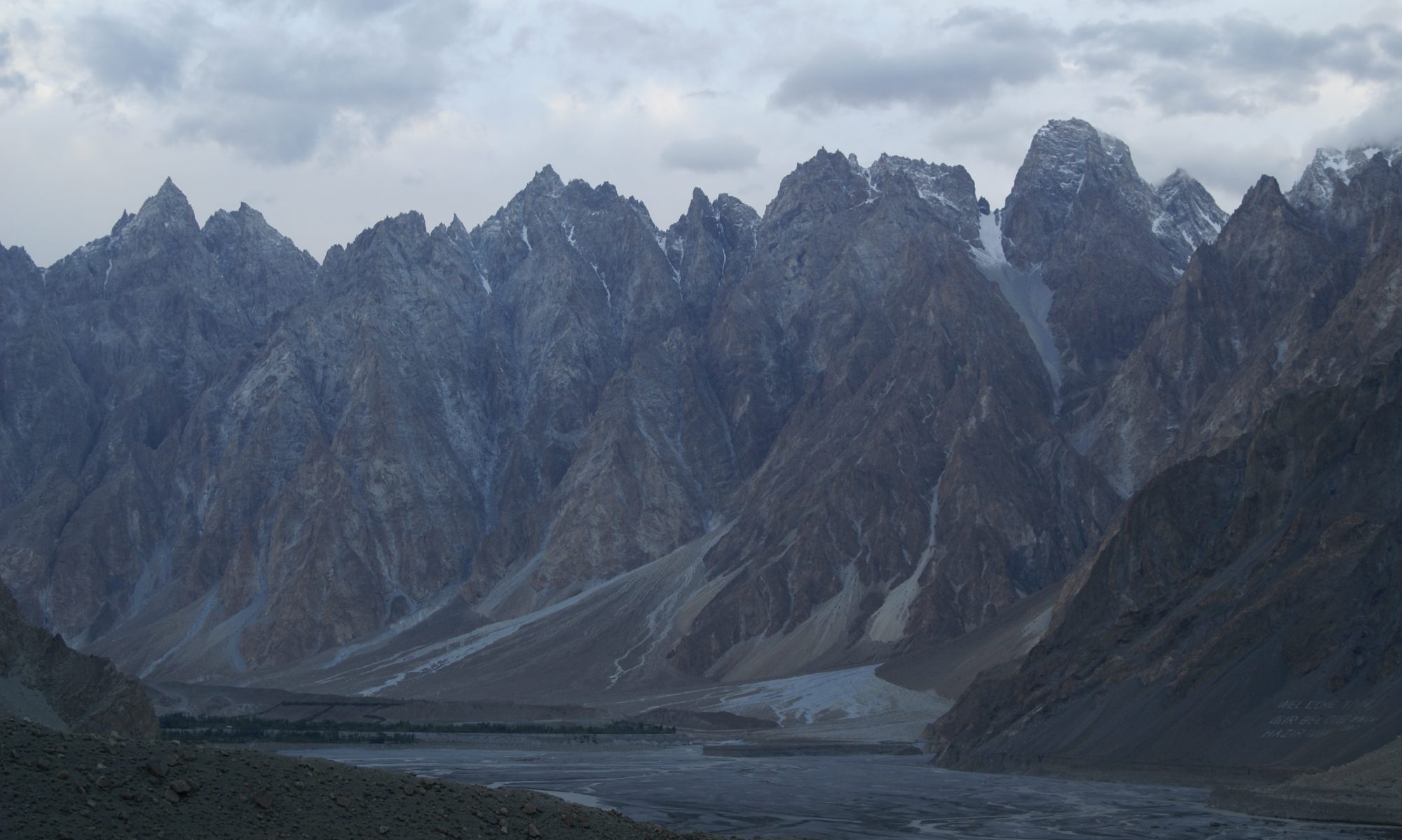
The third day we climbed to Spider Col. We left camp before nine and the snow was firm but our steps felt secure. We stopped about every half-hour to rest and ascended under warm sun and clear skys. We took off our packs a couple of times to explore the rocks in the side walls of the gully, leaving the packs anchored to an ice axe. At the top we dropped our packs and followed the trail on around looking for the mine adit. We never found the mine but could see a route down that didn’t involve walking down the snowfield. (Manning says that the mine is about a quarter mile from the Col, but we went a good three-quarters of a mile before deciding to forego a long steep snow patch.) We were also looking for the nests of tourmaline needles that Crowder & Tabor say are in the rocks around the Col, but we didn’t find them either. We had lunch and then hiked back over the Col to look down into Phelps Basin. After poking around the bivy sites at the Col for a while, we decided that the snow was as soft as it was going to get and we started our descent to Lyman Lake. This is the crux of the trip in terms of technique – the first hundred feet was steep and there was another steep section about half way down where the fall line changed. My steps went in about an inch – Wills weren’t as deep because he didn’t have as much weight driving them. We both did fine, though, and we pretty much plunge-stepped the full length of the main snow field to a gap in the moraine where we could cross rocks to a lower snow field. We noticed a family of mountain goats high on the ridge but they weren’t paying any attention to us. We descended the lower snowfield (avoiding some icy patches and noticing incipient “crevasses”) and then descended about four hundred feet on rubble and boulders to the lake shore. We sat by the lake for quite a while looking at the Lyman Glacier and playing with bits of ice (“bergy bits”.) In the middle of the afternoon we started out beside the lake and followed the watercourse down to the outlet of upper Lyman Lake. We picked up a trail about a mile above the outlet, about where we started to see trees again. We had some trouble finding a good way across the outlet creek, but the best campsite we could find was on the other side so we got ourselves and our packs over and camped on the moraine below the upper lake. Words aren’t adequate to convey how special this place is – the whole valley from the snout of the glacier to the moraine where we camped is a series of old moraines and behind each one is a little lake. The stream meanders around between them and the vegetation goes from trees and grass at the moraine to bare rubble near the glacier in a gentle graduation. Our tent site wasn’t exactly flat – it sloped down to our heads and we both wanted to roll toward the middle. There were also clouds of gnats. It was, however, near water. The freeze-dry was chili-mac with beef. We left the tent door open to see the stars,but decided to close it as we were reading because of a breeze.
The fourth day dawned wet – as in steady drizzle. We packed up and boulder-hopped on wet rocks to get down to the lower Lyman Lake. We picked up the trail at the bottom of the boulder field and walked along the lake shore in the rain to the outlet where we found a sheltered spot to pitch the tent. It rained all afternoon but we had reading material so we just holed up in the tent and stayed dry. We set up the stove just outside of the vestibule and our freeze-dry was black bart chili.
The fifth day was sunny and warm so we started by drying bedding and the tent in the sun. Then we hiked down to Hart Lake. The trail was good but long – something like four and a half miles. It descends with a lot of switchbacks from sub-alpine into jungle vegetation. The huckleberries around Lyman Lake were exceptional. Lower down they changed to salal which isn’t as tasty, but there were lots of excellent wild raspberries and some salmon berries. There is a magnificent view of the Railroad Creek waterfall at Crown Point. We had lunch at the Rebel Campsite and even though Crowder & Tabor say the camping is better there than at the lake, we decided to go on for the next mile. We found a fine tent site at Hart Lake even if it was almost right on the trail. It was so hot that even Will didn’t want to get in the tent that afternoon. We washed legs and hair in the lake and walked along the shore. We admired the cliffs of Bonanza. We sat by the water and read. When some horse people stopped right in our camp to adjust their tack we went back to the tent to protect our turf. It took them a long time to figure out that they and their dog weren’t welcome – by which time Will had fallen asleep in the hot tent. I had tea and read for a couple of hours before a dinner of Katmandu Curry freeze-dry.
The sixth day we walked the remaining three miles to Holden Village. We (or at least I) continued to snack on raspberries. We startled at least two bears during our walk – we could hear them tearing through the brush but didn’t get to see them. When we came to the wilderness boundary we saw the camp sites (and the horse people from the day before) but I wasn’t sure if that was the ballpark so we continued toward Holden. After about half a mile we found a sign directing us back the way we came so we returned and claimed a campsite right on the edge of the field. Later we were joined by a German woman who seemed anxious for company. The middle of the ballpark had been set out as a labyrinth (using twine and sawdust) and after reading about the meditative process we followed it to its center. Will and I agreed that it felt a lot like hiking, both physically and metaphysically. We wandered on into Holden and registered for the next day’s bus. Knowing that our last remaining freeze-dry was chicken primavera, Will prevailed on me to have dinner in the village – spinach lasagna.
Holden is a collection of buildings built in the 1930’s to house miners. There is a big hotel building with a dinning hall seating a couple hundred people and maybe six detatched lodges. There are assorted outbuilding housing workshops, a school, etc. There is a post office and store where we were able to buy candy and black and white film. The Village houses a Lutheran retreat center and must have some paid staff but it seemed that most of the crew was volunteer – mainly teenage girls. There was a prayer before dinner and some “camp songs” after, but nothing particularly objectionable. We toured the portal museum where there were some artifacts from the mine, some local records and curiosities, and a lot of amateur geology. The best pieces were the snow cats that are still in service – three bombardiers from the late forties or early fifties still used when the road can’t be plowed. They look like 1940 Fords with sloping prow-shaped rear ends. One of them had a series of port holes curving down the sides. Steering was with runners. The state and federal land management and environmental agencies are reopening the mine, ostensibly to combat water pollution. I’m not sure how going underground fits into that process, and it occurrs to me that the ore body has been leaching away for many, many years without any regulation. The guys (and women) on the project sure seemd to enjoy the work, though. We also walked through the site of the miners village and considered what our neighborhood would look like fifty years after the wilderness was allowed to return.
The morning of the seventh day we packed up and walked into the village where we tagged our packs for the fast boat to Chelan. We hung out with the fat chipmunks until the bus left and then rode the twelve miles to Lucerne. We had about an hour in warm sun to wait for the Lady Express and then had a two hour ride to the lower end of the lake. I spent the trip evesdropping as one of the teenage volunteers described her recreational drug and psychotherapy experiences to her mom. In Chelan we discovered that the Mapquest map and directions were screwed up – after walking three miles in the wrong direction. We caught the bus back out to our motel, but the driver forgot to let us off and took us almost a mile beyond the Best Western, so we walked back – probably doing five miles with our packs the day after the trip was supposed to be over! We didn’t have a car and didn’t want to walk the three miles into Chelan so we weren’t pleased to find that the hotel didn’t have a restaurant. We ended up settling for burgers and milkshakes from EZ burger, not the meal I was looking forward to at the end of the trip. The shower felt good, through. Odette showed up at about 7:00, much earlier than I had anticipated. She hadn’t eaten so we went into town and had desert with her.
The eighth day, Saturday, was cloudy and cool. We went to the Echo Ridge nordic ski area and did the eight and one-half mile mountain bike loop in the Kirkendall book. It was really good fun with enough climbing to feel like we’d gotten a workout. No freeze-dry that night either and I finally got my steak and a beer.
The ninth day we drove up to Shady Pass and I rode the bike down into the Entiat valley. Once again it was cloudy and cool with some periods of rain. Will put up a major fuss but ended up riding about five miles with me – downhill. Odette drove. I did about two miles of steep climbing and about fourteen miles of wild downhill on good dirt roads. I decided that it was almost as good as skiing.
The tenth day, Labor Day, dawned sunny but with big dark clouds covering the northern half of the sky. Even though Will was unhappy that he wasn’t going to get the water park he’d been looking forward to, we packed up early and drove back to Seattle.
Here are some images from our trip. (Will carried his digital camera but only remembered to take pictures on a couple of days, so the first few images are in color and the rest are black & white, developed and printed by Will and me and then scanned)
Here is the equipment list we used to prepare for the trip.
Here is a book list related to this area.